Polar Vortex Collapse Forecast 2026: Is a New ‘Beast from the East’ Looming for the UK?
As of 23 January 2026, the meteorological landscape across the Northern Hemisphere is shifting rapidly. The UK Health Security Agency (UKHSA) has issued Yellow Cold-Health Alerts for Northern England, signaling a sharp transition to freezing conditions. This is not just standard winter variability; it is the direct result of a significant stratospheric disturbance, often called a “polar vortex collapse”, that began in mid-January.
For transport planners, energy analysts, and residents across the UK, understanding this polar vortex collapse forecast is critical. We are moving from a period of mild Atlantic flow into a volatile “battleground” scenario that could define the remainder of winter 2026.
Here is the technical breakdown of the stratospheric split, the confirmed Met Office outlook for February, and the specific actions required for safety and logistics.
The Science of the 2026 Polar Vortex Split
To forecast the weather on the ground, we first must look 30 kilometres up. The Stratospheric Polar Vortex is a band of strong westerly winds circling the Arctic, typically keeping cold air locked in the north. When these winds decelerate or reverse, we see a Sudden Stratospheric Warming (SSW) event.
What is Sudden Stratospheric Warming (SSW)?
An SSW occurs when temperatures in the stratosphere spike, sometimes by 50°C in just a few days. This rapid warming forces the vortex to slow down and lose its shape.
In mid-January 2026, data from the European Centre for Medium-Range Weather Forecasts (ECMWF) confirmed a significant warming event. While not a complete “reversal” initially, the vortex became severely stretched and displaced. Think of it like a spinning top losing momentum; it begins to wobble. This wobble disrupts the jet stream below, allowing high pressure to build over the North Atlantic and blocking mild westerly winds.
Why the 2026 Collapse is Different (The Eurasian Separation)
Forecasters are calling the current event the “Great Eurasian Atmospheric Separation.” Unlike the textbook 2018 “Beast from the East,” which saw a clean split, the 2026 event involves a displaced core moving toward Eurasia.
According to analysis from severe weather experts and the ECMWF “Mean Zonal Wind at 10 hPa” charts, this displacement is creating a lag effect. The initial stratospheric chaos happened in mid-January, but the tropospheric response, the actual weather we feel, is hitting the UK now, in late January, and will likely persist through February.
Forecaster’s Notebook: Reading the Signals
When analyzing the 10hPa zonal wind charts, we look for the line to drop below zero. In 2026, we observed a sharp deceleration, signaling a “weak vortex” state. This creates a negative North Atlantic Oscillation (NAO), which historically correlates with cold, blocked weather patterns over the UK roughly two weeks later.
UK Winter Weather Outlook: Late Jan to Feb 2026
The polar vortex collapse forecast for late January suggests a classic meteorological conflict.
The ‘Battleground’ Phase: Atlantic vs. Arctic Air
The Met Office outlook for 25 January to 3 February 2026 describes a “battleground” scenario. Mild, moisture-laden systems from the Atlantic are attempting to push east, while cold, dry air from the Arctic is digging in from the northeast.
Where these two air masses meet, we see the highest risk of significant snowfall. Currently, the boundary line sits across the northern half of the UK. This setup often results in:
- Stalling Fronts: Rain turning to snow over hills and continuing for hours in the same location.
- Temperature Contrast: Mild conditions in Cornwall (10°C) versus freezing conditions in Newcastle (-1°C) on the same day.
Snow Forecast: Which UK Regions are at Risk?
Based on current ensemble modeling, the risk zones are clearly defined for the final week of January:
| Region | Risk Level | Forecast Impact |
| Scotland (Highlands/Grampians) | High | Significant accumulations; potential transport disruption. |
| North East England | High | Wintry showers feeding in from the North Sea. Ice risk. |
| Pennines & Peak District | Moderate-High | Snow likely where Atlantic fronts stall against cold air. |
| Midlands & South East | Low-Moderate | Mostly cold rain, but risk increases if the cold block deepens. |
[Check the Official Met Office Snow Warning Map]
Official Cold-Health Alerts & Public Safety
The shift in weather patterns has triggered official government responses. Trustworthy data from public health bodies is essential for preparation.
Understanding the Jan 26–30 Yellow Alert
On 23 January 2026, the UK Health Security Agency (UKHSA) issued a Yellow Cold-Health Alert covering the North West and North East of England.
This alert is active from 6:00 PM on Monday, 26 January to 6:00 PM on Friday, 30 January 2026.
According to the UKHSA, this level of alert implies significant impacts on the health and social care sector. The plunging temperatures pose a “risk to life” for vulnerable populations, particularly those over 65 or with pre-existing respiratory conditions.
Are You Eligible for Cold Weather Payments?
The sustained cold triggered by the polar vortex displacement also activates financial support mechanisms. The Department for Work and Pensions (DWP) issues Cold Weather Payments when the average temperature is recorded as, or forecast to be, 0°C or below for seven consecutive days.
As of mid-January 2026, over 700,000 households had already qualified. With the current forecast extending freezing conditions through the end of the month, more postcodes in Northern England and Scotland are likely to trigger the £25 payment.
[GOV.UK Cold Weather Payment Checker]
Sector-Specific Impacts: Energy, Transport, and Logistics
For professionals in logistics and energy, a polar vortex collapse forecast translates directly to operational risk.
Energy Demand Spikes and the 2026 Price Cap
Energy analysts must account for “thermal inertia.” Buildings lose heat rapidly during blocked high-pressure events due to clear night skies and radiative cooling.
With the January to March 2026 energy price cap set at approximately £1,758 per year for a typical household, demand is price-sensitive. However, during a sustained polar event, demand becomes inelastic, people heat their homes regardless of cost to avoid freezing. Grid operators should anticipate demand spikes between 17:00 and 20:00 that exceed typical seasonal baselines by 5-10%.
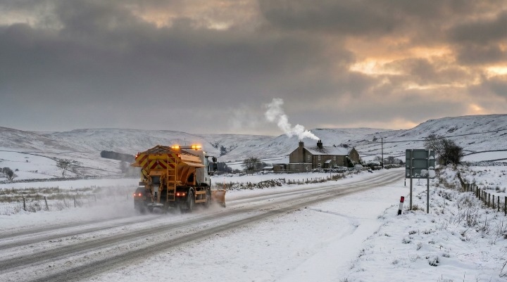
Transport Planning: Managing the 2°C Black Ice Threshold
For logistics planners moving goods via the M62 or A1(M), the air temperature is less important than the dew point.
Pro-Tip for Logistics Managers:
During this specific “battleground” phase (Jan 27–29), monitor the dew point closely. When the road surface temperature is below zero and the dew point is roughly 2°C below the air temperature, black ice forms rapidly, often invisibly.
- Action: Schedule haulage runs for daylight hours where possible.
- Action: Ensure fleets operating in the North East carry winter kits, as standard grit may be washed away by the initial rain preceding the freeze.
Looking Ahead: Preparing for a Volatile February
The polar vortex collapse forecast for 2026 does not end on January 31. The stratospheric signal suggests that high-pressure blocking could persist well into February. This increases the likelihood of further cold air outbreaks and limits the influence of mild westerlies.
While 2026 is projected to be another warm year globally (1.46°C above pre-industrial levels), these localized “weather whiplash” events are a hallmark of our changing climate. The vortex collapse serves as a reminder that averages hide extremes.
Next Step: Don’t rely on apps that look 10 days ahead. Check the live radar every morning. If you manage vulnerable people or logistics fleets, treat the Yellow Alert as a confirmed hazard, not just a possibility.
FAQs
Is there a polar vortex collapse in 2026?
Yes. In mid-January 2026, a Sudden Stratospheric Warming event caused the polar vortex to stretch and displace. This disrupted the usual westerly winds, leading to the cold weather patterns seen in late January.
What does a polar vortex collapse mean for UK weather?
It typically increases the chance of “blocking” patterns. High pressure blocks mild Atlantic air, allowing cold Arctic or easterly winds to dominate. This leads to colder temperatures, frost, and a higher risk of snow.
When will it snow in the UK in February 2026?
The highest risk for snow is during the transition periods where cold air meets moist Atlantic air. Current forecasts pinpoint late January and the first week of February as high-risk windows, especially for the North and Scotland.
How long does a Sudden Stratospheric Warming event last?
The warming event itself in the stratosphere can last a few days to a week. However, the impact on our weather (the tropospheric response) can lag by weeks and persist for a month or more, often affecting weather well into late winter.
What is the difference between a polar vortex and the jet stream?
The polar vortex is a high-altitude area of low pressure in the stratosphere. The jet stream is a current of fast-moving air lower down in the troposphere. A strong vortex keeps the jet stream strong and straight; a collapsed vortex causes the jet stream to meander, locking in cold weather.
Is the 2026 cold snap related to La Niña?
La Niña can influence global weather patterns, but the immediate trigger for the late January 2026 cold snap is the stratospheric disturbance (SSW). These global drivers often interact to amplify weather extremes.
How do I get the UK Cold Weather Payment?
You do not need to apply. If you are eligible (usually receiving Pension Credit, Income Support, or Universal Credit) and your postcode triggers a payment due to recorded freezing temperatures, the £25 is paid automatically into your bank account by the DWP.