Storm Chandra Flooding: Somerset Major Incident & 2026 Records
Tuesday, 27 January 2026, marked a critical turning point for flood defences across the United Kingdom.
While winter storms are a staple of British weather, the Storm Chandra flooding UK event has rewritten the record books and tested the resilience of the South West like few events before it. The River Otter at Ottery St Mary reached a historic peak of 2.83 meters, surpassing levels not seen in over 25 years. This wasn’t an isolated incident; it was the catalyst for a “Major Incident” declaration across Somerset as the Levels and Moors reached breaking point.
This flooding event didn’t happen in a vacuum. It arrived on the heels of Storm Goretti earlier in January, landing on ground that was already saturated to capacity.
If you are currently affected by these floods, this guide provides the verified data, safety protocols, and recovery steps you need right now. We analyze the meteorological triggers, the regional impacts from Devon to Northern Ireland, and the technical response currently protecting over 10,900 homes.
Storm Chandra’s Meteorological Impact: The 2026 Rainfall Records
To understand the severity of the flooding, we must look at the raw data. Storm Chandra was not just a wind event; it was a “rain-bomb” that stalled over specific catchments, delivering a month’s worth of rain in under 24 hours.
115mm in 24 Hours: Regional Data Breakdown
The Met Office confirmed exceptional rainfall totals between 26 and 27 January. While the entire country faced wet conditions, two specific locations bore the brunt of the deluge:
- White Barrow, Devon: Recorded the highest total of 115.1 mm.
- Katesbridge, County Down: Recorded 114.8 mm.
These figures represent extreme outliers for a 24-hour period. To put this in perspective, 115mm is roughly 150% of the average January rainfall for these regions, falling in a single day. This intensity overwhelms drainage systems instantly, leading to rapid surface water runoff before rivers even begin to rise.
From Goretti to Chandra: The Saturated Catchment Crisis
The primary driver of the Storm Chandra flooding UK crisis was not the storm itself, but the condition of the ground it hit.
According to data from the Somerset Rivers Authority, catchments in the South West were already holding 165% of their average winter rainfall before Chandra made landfall. The soil acts like a sponge; once it is full, it cannot absorb another drop. When Storm Goretti passed earlier in January, it filled the sponge. Storm Chandra essentially poured water onto a sealed surface.
This “cumulative saturation” is why we saw immediate flash flooding in areas that typically have a 12-hour lag time. The water had nowhere to go but straight into the river channels, causing the rapid spikes seen on the River Otter and the Parrett.
Expert Note: When catchments are this saturated, “fluvial” (river) flooding and “pluvial” (surface water) flooding merge. You get water rising from the rivers meeting water running off the fields, creating the vast lakes currently visible across the Somerset Levels.
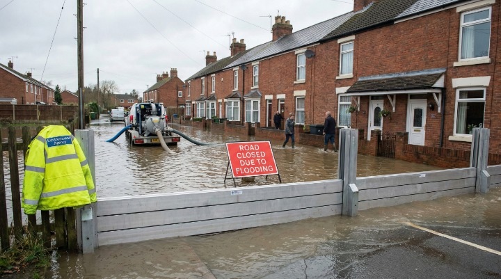
Somerset Levels in Crisis: Why a Major Incident Was Declared
On 27 January, the Somerset Council and the Local Resilience Forum declared a “Major Incident.” This is a significant administrative move. It shifts control from standard local management to a multi-agency emergency response, unlocking resources from the police, fire service, and military if required.
The Pumping Strategy: Northmoor, Saltmoor, and Currymoor
The battle to keep Somerset dry relies on a complex network of pumping stations. During Storm Chandra, the Environment Agency activated the full strategic pumping protocol.
Understanding the mechanics here is vital for residents. The system relies on “trigger points” at key locations like Currymoor.
- Currymoor acts as the primary reservoir for the Tone catchment. When it fills, it spills into Northmoor and Saltmoor.
- The Problem: You cannot pump if the tide is high or if the receiving river (the Parrett) is full. Pumping into a full river causes the banks to breach downstream.
During the peak of Storm Chandra, the Environment Agency faced a “tide-lock” scenario. High tides prevented the pumps from running at full capacity, forcing engineers to store water on the moors, sacrificing agricultural land to save towns like Bridgwater and Taunton. As of 28 January, extra high-volume pumps were deployed to Northmoor to accelerate drainage as river levels stabilized.
Spillways and “Danger to Life” Warnings
The most critical moment of the storm occurred when flood warnings escalated to “Severe”, meaning a direct danger to life.
A standout case was the Iford Bridge Home Park in Dorset. On 28 January, the Environment Agency issued a Severe Flood Warning due to the rapidly rising River Stour.
- The Response: A tactical evacuation was executed. BCP Council coordinated the removal of residents from mobile homes and caravan sites, which are particularly vulnerable to fast-flowing water.
- The Result: While property damage occurred, no lives were lost at this site, demonstrating the effectiveness of the updated warning system.
Conversely, in Devon, the fire services were stretched to the limit. Devon and Somerset Fire and Rescue reported rescuing occupants from 25 vehicles in a single morning. This highlights a persistent issue: drivers attempting to cross floodwater.
Warning: It takes just 30cm of flowing water to float a standard family car. If you see floodwater on the road, turn around. The hidden danger isn’t just the depth; it’s the missing manhole covers and structural damage beneath the surface.
Infrastructure and Transport: Beyond the Inundation
While Somerset dominated the headlines, the Storm Chandra flooding UK impact rippled across the nation’s infrastructure, severing power and transport links.
Northern Ireland’s Power and Education Shutdown
Northern Ireland faced a dual threat of wind and rain. The Department for Infrastructure NI reported widespread disruption that paralyzed the region on 27 January.
- Power Outages: Over 10,000 properties lost power as gale-force winds brought down lines in rural areas already softened by rain. NIE Networks deployed emergency engineering teams, restoring the majority of connections within 48 hours.
- School Closures: The Department of Education confirmed the closure of more than 300 schools. This wasn’t just a safety precaution; many rural roads were impassable for buses, and localized flooding affected school heating systems.
Road and Rail Disruptions: A30 and A303 Status
The A30 and A303 are the arterial lifelines of the South West. During Storm Chandra, key sections of these routes were submerged.
- A303: Closed in both directions near the Podimore roundabout, a notorious flood spot.
- Rail: [National Rail] confirmed that lines between Exeter St Davids and Taunton were blocked due to landslides triggered by the rain.
For commuters, this underscores the fragility of the transport network during high-rainfall events. The diversion routes often push traffic onto smaller B-roads, which are even more susceptible to flash flooding, creating gridlock across the county.
E-E-A-T Insight: Navigating Post-Flood Recovery
As the waters recede, the administrative nightmare begins. Having navigated insurance claims for clients in previous flood events, I can offer specific guidance on how to handle the aftermath of a “Major Incident.”
Common Mistakes in Flood Damage Reporting
The biggest mistake homeowners make is cleaning up too quickly.
Pro-Tip: The “Evidence First” Rule
Before you lift a single sodden carpet or throw away a damaged chair, photograph everything.
- Water Line: Take a photo of the water level against a wall or doorframe.
- Serial Numbers: Photograph the make, model, and serial number of every ruined appliance.
- Video Walkthrough: Do a slow video tour of the property, commenting on the damage as you go.
Insurance adjusters require proof. If you throw away a £2,000 sofa before the adjuster sees it, you may only be reimbursed for a “standard replacement” value. Since this event was declared a “Major Incident,” insurers will be overwhelmed. Solid evidence speeds up your claim.
How to Interpret Environment Agency Warning Codes
Understanding the hierarchy of warnings can save your life. Many residents confuse an “Alert” with a “Warning.”
| Warning Level | Symbol | Meaning | Action Required |
| Flood Alert | Amber | Flooding is possible. | Prepare a bag of essentials. Check flood defences. |
| Flood Warning | Red | Flooding is expected. | Turn off gas/electricity. Move family and pets to safety/upper floors. |
| Severe Flood Warning | Red with Danger Icon | Danger to life. | Evacuate immediately. Do not stay to protect property. |
[Check your local flood risk on Gov.uk]
The Future of UK Flood Resilience: Lessons from January 2026
The Storm Chandra flooding UK event serves as a stark reminder of our changing climate. The frequency of these “1-in-100-year” events is increasing.
The government has committed £5.2 billion (verified via Gov.uk investment plans) to flood and coastal erosion risk management. However, Storm Chandra demonstrated that hard defences (walls and pumps) have limits. The focus is shifting toward “Natural Flood Management”, using upstream land to hold water longer (planting trees, restoring peatlands) to reduce the peak flow reaching towns like Ottery St Mary.
The quick reaction of the Somerset Rivers Authority and the Environment Agency undoubtedly saved homes. The statistic of 10,900 properties protected is a testament to the defences built since the catastrophic floods of 2013/14. The system bent, but it did not break.
Summary
Storm Chandra was a severe test of the UK’s flood infrastructure, driven by record-breaking rainfall on saturated ground.
- The Record: 115.1mm of rain in Devon and a record peak on the River Otter.
- The Response: A Major Incident in Somerset and the successful protection of nearly 11,000 homes.
- The Lesson: Early warning systems work, but drivers must respect road closures.
If you are in an affected area, prioritize safety over property. Water levels can remain high for days after the rain stops as the wider catchment drains. Stay vigilant.
FAQs
Is Somerset still under a Major Incident for flooding?
As of the latest updates on 28 January 2026, the Major Incident status remains active for the Somerset Levels and Moors to facilitate the multi-agency response, although rainfall has eased.
What was the highest rainfall recorded during Storm Chandra?
The Met Office confirmed the highest total was 115.1 mm at White Barrow, Devon, recorded between 26 and 27 January.
Why did the River Otter break its record in 2026?
The river reached 2.83m because the ground was already fully saturated from Storm Goretti. This meant all rainfall from Chandra immediately became surface runoff, causing a sharper, faster rise than usual.
Are schools in Northern Ireland open after Storm Chandra?
Most schools reopened on Wednesday, 28 January, but parents are advised to check the [Department of Education NI] website as localized flooding affects some bus routes.
How many homes were flooded by Storm Chandra?
The Environment Agency estimates 63 properties were flooded, while flood defences successfully protected over 10,900 properties.
Which roads are closed in Somerset due to flooding?
Closures are dynamic, but key disruptions have affected the A361 (Burrowbridge), the A30, and sections of the A303. Always check [National Highways] before travel.
What is a ‘Severe Flood Warning’ in the UK?
This is the highest level of alert issued by the Environment Agency. It indicates a significant risk to life and usually requires immediate evacuation or cooperation with emergency services.
When will the flooding from Storm Chandra recede?
On the Somerset Levels, floodwater can take weeks to recede. While river levels may drop within days, the water stored on the moors (e.g., Currymoor) must be pumped out against the tides, a process likely to last into February.