Riverbank Collapse Iford Playing Fields: Safety & BCP Council Updates
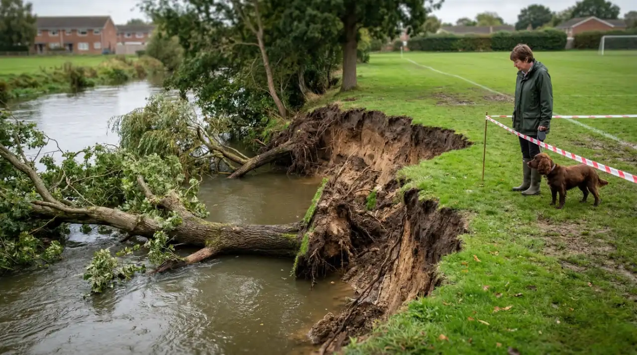
The sudden shift of the River Stour’s banks has left a popular Christchurch green space significantly altered. Following severe winds in late May 2025, a large section of the embankment gave way. A local resident photographed the damage on 29 May 2025, capturing several large trees that had fallen directly into the river channel. Whether you walk the dog, cycle, or paddleboard, understanding the current hazards and official BCP Council guidance is essential for your safety this summer.
Following strong winds in May 2025, a major riverbank collapse occurred at Iford Playing Fields in Christchurch. Large sections of earth and several trees fell into the River Stour. BCP Council is actively monitoring the site, which remains a natural process of river erosion, while advising locals to exercise caution.
Key Takeaways
- Overnight collapse triggered by severe winds in late May 2025.
- Multiple trees became submerged in the River Stour.
- BCP Council was notified and is currently monitoring the site.
- Erosion in this specific area is part of natural river processes.
- Caution is required for walkers, paddleboarders, and summer swimmers.
Quick Start: Immediate Safety Checklist
Before heading to the river, run through this quick observation checklist to ensure the area is safe for your planned activity:
- [ ] Have there been severe winds or heavy rain in the past 48 hours? If yes, proceed with high caution.
- [ ] Are there visible, fresh cracks in the footpath parallel to the river edge?
- [ ] Are large trees leaning heavily towards the water?
- [ ] Have official BCP Council warning signs or tape been posted?
- [ ] Is the water level unusually high, obscuring the exact edge of the bank?
Common Mistake: Do not bypass or ignore any safety monitoring equipment or temporary barriers set up by BCP Council just to get a closer look at the damage.
What Caused the River Stour Bank Failure?
The Impact of Severe Weather on Soil Subsidence
Severe winds battered the Christchurch area just before the collapse. This weather weakened the riverbanks and caused the soil to lose cohesion.
Typical scenario example: Following severe strong winds, weakened riverbanks can easily lose structural integrity. Edge-dwelling trees destabilise without firm soil, pulling large sections of earth into the watercourse. This temporarily alters local currents and creates new physical hazards for paddleboarders and swimmers.
You can read more about how national bodies manage these weather-related risks via the Environment Agency main river guidance.
Official BCP Council Response & Ongoing Monitoring
Local residents quickly raised safety concerns because the area is highly popular for summer activities. In response, Bournemouth, Christchurch and Poole (BCP) Council received official notification and confirmed they are actively managing the situation.
To handle the incident, the council follows three main steps:
- Assess: Evaluate the scale of the collapsed section and the fallen trees.
- Monitor: Check the site regularly for further rapid erosion.
- Advise: Consult with environmental partners to decide on future actions.
A BCP Council spokesperson explained: “Whilst this is an unusually large section it is part of the natural processes of the river.” They added: “We are monitoring and seeking advice from partner organisations to determine next steps.”
Typical scenario example: When a collapse occurs, local authorities must balance public safety with environmental policy. Councils assess the site to decide whether costly structural intervention is required, or if the erosion should simply be allowed to continue as a natural river process.
Activity Risk Levels at Iford Playing Fields
The riverbank collapse has changed how people can safely use the River Stour and its nearby paths. Because the site is a recognised recreational area monitored by regional groups like the Urban Heaths Partnership, safety remains the top priority.
Different activities carry different levels of risk right now. Review the table below before planning your visit.
| Activity Type | Current Risk Level | Recommended Precaution / Alternative Route |
| Dog Walking | Medium | Keep dogs on a short lead near the diversion zones. Stay clear of the bank edge. |
| Cycling | Medium | Dismount your bike if the path narrows significantly near the affected area. |
| Paddleboarding | High | Stay vigilant for newly submerged debris, specifically the fallen trees. |
| Summer Swimming | High | Select an alternative, stable entry point well away from the recent erosion zone. |
Mid-Article Summary
- The recent bank collapse is unusually large but remains a natural river process.
- Direct hazards include newly submerged trees and unstable walking edges.
- Always check for official BCP Council signage before entering the water or walking near the bank.
Step-by-Step Guide for Safe River Recreation
Iford Playing Fields and the River Stour corridor are key local green spaces designated for access improvements under the BCP Local Plan. While the area remains open, you need to adapt your routine.
Follow these steps to navigate the area safely:
- Assess the weather: Check local wind and water levels before arriving at the playing fields.
- Control your pets: Keep dogs on a short lead when navigating the paths near the collapsed embankment to prevent accidents.
- Scout the water: Paddleboarders must actively look for newly submerged branches or tree trunks in the water channel.
- Walk your bike: Cyclists using the river corridor should dismount and walk when passing narrow or cracked sections of the path.
- Find safe water entry: If you plan to swim, do not jump in near the collapsed area. Find a stable bank far upstream or downstream.
How to Report Further Erosion or Hazards
Riverbanks can change rapidly. If you spot further rapid deterioration of the bank, report it directly to the BCP Council environment team.
Use this simple decision tree if you notice a new hazard:
- Did you spot a new, large section of collapsed bank or a fallen tree blocking the river?
-
YES -> Is anyone in immediate physical danger or trapped?
-
YES -> Call 999 immediately.
-
NO -> Report the exact location using a map app to the council via the BCP Council Environment Reporting Portal.
-
-
NO -> Continue to enjoy the recreational area responsibly, maintaining a safe distance from the river e
-
Summary
The River Stour’s natural erosion has temporarily changed the environment at Iford Playing Fields. Strong winds caused a large section of the bank and several trees to fall into the water. By staying alert and following official BCP Council guidance, locals can continue to enjoy this popular green space safely.
Next Steps:
- Review the BCP Council website for the latest updates on tape or barrier removals.
- Share this safety checklist with local community groups, dog walking clubs, and paddleboarding teams.
- Report any new, rapid bank deterioration immediately to local authorities.
FAQs
When did the riverbank collapse at Iford Playing Fields happen?
The collapse occurred overnight following strong winds in late May 2025. A local resident first photographed the damage on 29 May 2025.
Is it safe to paddleboard on the River Stour near Iford?
You can still paddleboard, but you must exercise extreme caution. Several trees fell into the river during the collapse, creating new submerged hazards.
What is BCP Council doing about the fallen trees?
The council is actively monitoring the affected site. They are consulting with partner organisations to determine the best next steps for safety and environmental management.
Can I still walk my dog at Iford Playing Fields?
Yes, but you should keep your dog on a short lead when walking near the collapsed embankment. Avoid walking directly on the edge of the River Stour.
Why do riverbanks collapse suddenly?
While this collapse was unusually large, BCP Council confirmed that erosion in this specific area is a common occurrence. It is part of the river’s natural processes, often accelerated by strong winds and heavy rain.
Are there path diversions in place at Iford?
BCP Council may erect temporary barriers or signs around the most unstable edges. Always obey local safety monitoring equipment and do not cross taped-off zones.
How does this affect the BCP Local Plan for green spaces?
Iford Playing Fields and the adjacent river corridor remain key local green spaces designated for infrastructure and access improvements. The council will factor this natural erosion into their long-term management plans.
Who monitors the environmental health of the River Stour?
The site is a recognised recreational area monitored by regional environmental initiatives, including the Urban Heaths Partnership, alongside the local council.