Storm Dave: Will 90mph Winds Ruin Easter Travel?
Millions are hitting the roads this Easter bank holiday. But a rapidly deepening low-pressure system threatens to throw a major spanner in the works. Meet Storm Dave. It is arriving from the Atlantic with severe gales, heavy rain, and even localised blizzard conditions for northern parts of the UK. Whether you are towing a caravan or simply visiting family, understanding the exact warning zones is vital. You need to know peak impact times and alternative routes to keep your weekend safe.
Storm Dave is a severe low-pressure system hitting the UK over the 2026 Easter weekend. The Met Office has issued yellow wind warnings for Scotland, Northern Ireland, North Wales, and northern England. Peak impacts, including 50–70mph gusts and northern Scotland snow, will occur from Saturday evening through Sunday morning.
Key Takeaways
- The peak danger window runs from Saturday evening (4 April) to Sunday morning (5 April).
- Yellow severe weather warnings currently cover Scotland, Northern Ireland, North Wales, and northern England.
- Winds of 50–60mph are widespread across the warning areas.
- Blizzard conditions bring a risk of closing high-elevation Scottish roads.
- High-sided vehicles face extreme buffeting on exposed routes and bridges.
- Adjust your travel plans on Saturday evening and Sunday morning if crossing exposed bridges in Scotland, Northern Ireland, or North Wales.
Quick Start: Easter Travel Decision Tree
- Are you travelling Saturday evening or Sunday morning?
-
No: Proceed with normal caution.
-
Yes: Go to step 2.
-
- Are you travelling in Scotland, Northern Ireland, North Wales, or northern England?
-
No: Expect breezy but mostly drier conditions.
-
Yes: Go to step 3.
-
- Are you driving a high-sided vehicle or taking an exposed coastal route/bridge?
-
-
Yes: Consider delaying travel or finding a sheltered inland route due to 50-70mph gusts.
-
No: Proceed with caution, allow extra time for potential road/rail delays.
-
When and Where Will Storm Dave Hit the UK?
Storm Dave is moving eastwards fast. You can track the exact path on the Met Office live warning map.
The system is bringing heavy snowfall to the hills of northern Scotland. Accumulations of 5–10cm of snow are expected above 200m elevation. In the most exposed coastal areas of Scotland, gusts of up to 80-90mph are possible.
Comparing Regional Impacts
| Region | Expected Wind Gusts | Snow Risk | Primary Hazards |
| Northern Scotland | 60–90mph | High (5–20cm above 200m) | Blizzards, coastal waves, power cuts |
| Southern Scotland & NI | 50–70mph | Low | Bridge closures, ferry cancellations |
| North Wales & N. England | 50–60mph | None expected | Buffeting crosswinds, minor debris |
Navigating the Easter Travel Disruption
The storm coincides with expected peak Easter bank holiday travel. This will impact driving conditions across the north and west of the UK. Transport Scotland expects disruption across the national transport network. You might see short-notice cancellations across road, rail, air, and ferry services.
“By Saturday afternoon winds will strengthen significantly, with gusts of 60-70mph expected at times across parts of Scotland,” the Met Office confirms.
The RAC is also issuing clear advice. “Drivers shouldn’t underestimate the impact of the very strong winds that are forecast.”
3 Steps for High-Sided Vehicle Drivers
- Check structural restrictions. Verify if major crossings are closed to high-sided vehicles before you leave. Use resources like the Traffic Scotland live updates.
- Reroute inland. Avoid exposed coastal A-roads where crosswinds are strongest.
- Reduce speed and secure loads. If driving a high-sided vehicle or towing a caravan, reduce speed and grip the steering wheel firmly on exposed routes.
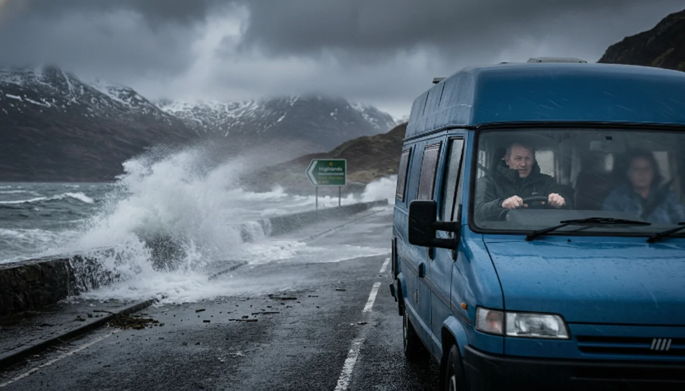
Take a typical scenario. A family driving a high-sided motorhome towards the Scottish Highlands for the Easter weekend faces severe buffeting crosswinds. They must reroute away from exposed coastal roads and bridges to avoid the 60-70mph gusts.
Common mistake: Assuming your ferry or train is running just because it is a bank holiday. Always check with your rail, air, or ferry operator before leaving home, as services may face short-notice cancellations.
Mid-Article Summary Box
- Storm Dave peaks Saturday night into Sunday morning.
- Major bridges are highly likely to restrict high-sided vehicles.
- Rail and ferry operators warn of short-notice cancellations.
- Weather conditions will settle by Easter Monday.
How to Prepare Your Property for Severe Gales
High winds cause damage. It is that simple. If you live in a yellow warning zone, act now. This applies to residential properties, static caravans, and campsites alike. The Met Office notes a slight chance of damage to buildings. Roof tiles might blow off. Mobile phone coverage could drop.
Take a typical homeowner in North Wales. They check their property ahead of Saturday evening. Following official warnings, they secure loose garden furniture. They prepare for potential brief power outages. By Sunday, the storm clears. Preparation pays off.
Check the UK Gov extreme weather prep guide for detailed advice.
Pre-Storm Property Checklist
- Check your specific location against Met Office yellow warning zones.
- Secure all loose garden furniture, trampolines, and bins.
- Park vehicles well away from large trees or vulnerable structures.
- Charge your mobile phone fully. Have a torch ready in case of power cuts.
- Avoid walking near sea fronts in warning areas. Large waves can throw beach material onto coastal roads.
The Science: Why is Storm Dave Deepening So Quickly?
Why is this storm so strong? Blame the jet stream. Colder air plunging from Canada is fuelling a powerful Atlantic jet stream. This fast-moving ribbon of air sits high in the atmosphere. It scoops up low-pressure systems and rapidly intensifies them. The result is a violent storm hitting our shores.
This rapid deepening creates the extreme winds. The Met Office warns of severe impacts, “…with the potential for gusts of 80-90mph in exposed coastal locations in Scotland.”
End Summary
Storm Dave brings a potent bout of winter weather right in the middle of spring holiday plans. It will be messy. Preparation is the best way to avoid the worst of the transport delays. Do not leave your safety to chance.
Next Steps:
- Check your local Met Office forecast before packing.
- Confirm your rail or ferry tickets are still valid just before leaving.
- Download your travel operator’s app for real-time push notifications.
FAQs
Is Storm Dave going to cancel my flight?
It is possible. The Met Office expects potential delays or cancellations across air travel, especially in northern UK airports. Check with your airline.
Will the Easter bank holiday weekend be a washout?
No, not entirely. Conditions are expected to become drier and more settled by Easter Monday as a brief ridge of higher pressure follows the storm.
Where is the yellow wind warning in place?
The Met Office has issued yellow wind warnings for Scotland, Northern Ireland, North Wales, and parts of northern England.
How much snow will Storm Dave bring?
Alongside strong winds, heavy snowfall will hit the northern Scottish hills. Expect 5–10cm above 200m elevation. Localised pockets might see 10–20cm, causing blizzard conditions.
Are bridges closed in Scotland due to Storm Dave?
Transport Scotland warns of disruption. Bridge closures are highly likely for high-sided vehicles across Scotland and other warning zones due to severe crosswinds.
What should I do if I experience a power cut?
Keep your phone charged. Have a battery-operated torch ready. The Met Office warns of potential power cuts and disruption to mobile phone coverage during the peak storm window.
Is it safe to drive a motorhome this weekend?
The RAC advises drivers to take extra care. Exposed routes carry a severe buffeting risk for high-sided vehicles. Consider delaying travel or finding sheltered inland routes.